Glaciology is the study of the physical characteristics and movements of glaciers. This uncommon yet longstanding discipline dates back to the 19th century, encompassing regions across the globe from the island of Greenland to the Himalayan mountains. Dr. Jason Gulley, a professor in the College of Arts and Sciences School of Geosciences, has devoted his career to understanding and contributing to this field.
Dr. Jason Gulley, associate professor in the School of Geosciences. (Photo courtesy of Dr. Jason Gulley)
Gulley, now an associate professor of geology, arrived at USF in 2015. Beyond his teaching role, he is widely recognized for his extensive 19-year tenure as a researcher and explorer of glaciers worldwide.
Part of Gulley’s research focuses on carbonate landscapes, including aquifers and islands formed entirely from corals. However, the main focus of his research is understanding the impact of climate change on glaciers and ice sheets experiencing surface melting. Although these research areas may initially seem unrelated, they share a common thread — each of their geological environments has caves that help regulate water flow.
Gulley began researching caves and glaciers during his undergraduate years at Eastern Kentucky University. He has since leveraged the knowledge gained from those early experiences to embark on more challenging expeditions in recent years.
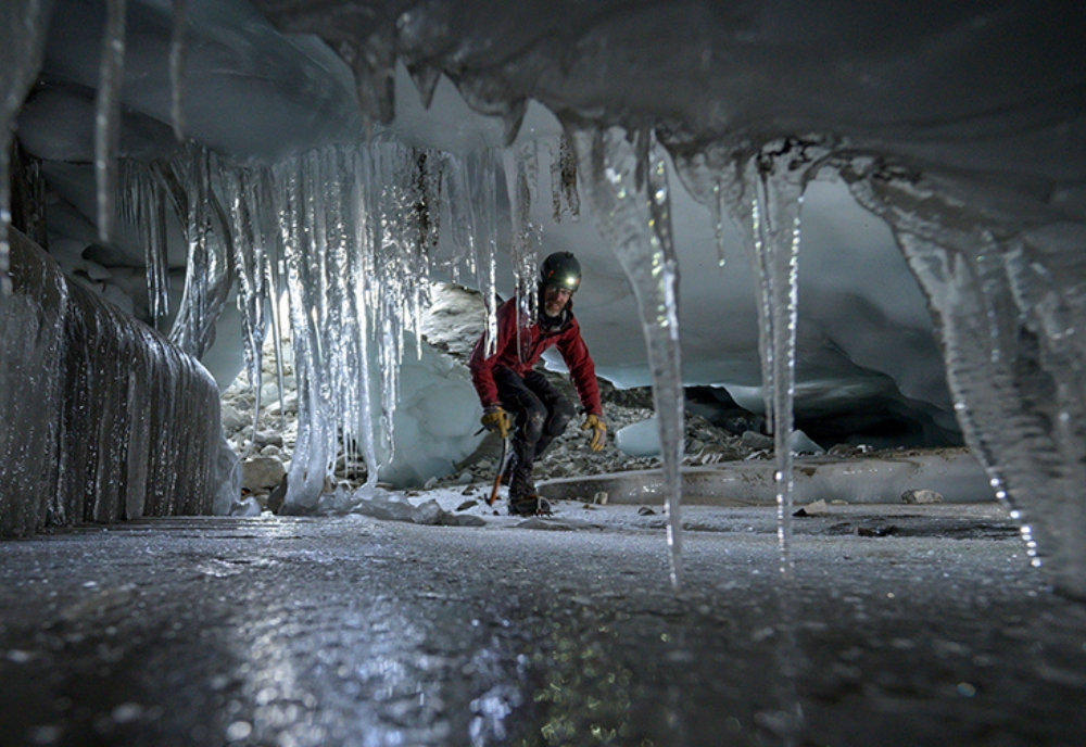
“I actually started working with glacier caves as an undergraduate. My background had been in limestone cave exploration and mapping, but my fascination led me to venture into scuba diving in underwater caves. Through these explorations, I found out that there were caves being formed inside glaciers, and that very few people understood how these caves formed. So, a lot of my research over the years has been directed towards understanding the fundamental processes that are that are driving cave formation inside glaciers,” Gulley said.
Gulley’s quest to understand these formations led him to the glaciers in the Himalayan Mountains, near the Mount Everest region. Glaciers in this region are formed primarily through avalanches, and contrary to popular belief, avalanches can contain as much rock and debris as snow. When the glaciers descend to lower elevations, the ice begins to melt leaving behind areas covered in debris.
While glaciologists thought the debris layer should insulate the glaciers underneath and protect them from melting, they found that debris-covered glaciers were melting as quickly as glaciers that lack debris. Gulley’s research has helped glaciologists understand this paradox.
Debris-covered glaciers have rolling surface topography that allows ponds to form in depressions.
On summer days, sunlight heats the water in the ponds and warm water melts ice under the debris.
“Meltwater ponds grow and expand over a number of years, and then they drain quickly and catastrophically through the ice. This process repeats to form new caves that can collapse and form new basins or lakes, and so on and so forth. Cave formation and lake drainage events in the Everest region are turning these glaciers into Swiss cheese and are literally rotting it from the inside out,” Gulley said.
During the expeditions, Gulley and his team map caves by establishing a survey station outside of a cave’s entrance. A team member then enters the tunnel with a flashlight to gauge the visible depth and to measure the azimuth – the inclination and distance from the station. Gulley and his team then use a laser rangefinder for distance, a compass for direction, and a notebook to build out a detailed map of the cave passages.
“The main reason that we're mapping the caves is because we're trying to provide a record of caves that used to exist and to understand how the landscape above them is changing. Typically, when people are mapping caves in more permanent environments, like limestone, they're using those caves to navigate. For us, it doesn't make a lot of sense to make a map that's used for navigation for a cave that's only going to last maybe a couple of years. We're using them to tell the story in the overall evolution of the glacier,” Gulley explained. “I've been working in Nepal since 2005 and there are whole sections of glaciers that I used to explore that are now gone. But what we've been able to do, is analyze the previous areas where we mapped a cave and conclusively draw a link between a cave collapse and a depression formation.”
Gulley has been working closely with The National Geographic Society, receiving funding from the organization for his last two major expeditions to the Everest region.
While Gulley works on big budget projects in other parts of the world, he explains obtaining funding for exploration-based research projects, like his work in glacier caves, can be difficult.
Larger funding organizations typically are more interested in supporting studies that require more extensive equipment, satellite imagery, or large datasets as opposed to the relative simplicity of Gulley’s work in the Everest region.
“Most of the work that I've been doing inside glaciers has been with an eye towards understanding how they're going to be impacted by future climate change scenarios” Gulley said.
“Our techniques are not very complicated, so it's really easy for large funding agencies to focus on really big or expensive studies. It’s very difficult to get funding for our expectations because what we ultimately want to do is to explore and study an environment that no one has worked in before. For the types of work that we've been doing in Nepal, we've been able to do it more successfully with these smaller National Geographic type grants,” Gulley explained. “The thing that I really like about working with National Geographic is, they make it really easy to communicate the science you're doing and the findings you're making as an explorer, to broader audiences. It allows us to open a door and communicate stories about climate change that we might not actually be able to reach if we weren't working with such a large and trusted brand.”
While Gulley has spent many years studying the glaciers in the Everest region, he has also been able to broaden his research to other areas of the globe. This interdisciplinary approach has led Gulley to discover new complexities in meltwater flows that have influenced the content of updated glaciology textbooks. Reflecting on the early phases of his glacier cave explorations, Gulley was surprised and challenged by the improvisational nature of the field.
“I started working on glacier cave issues in Nepal, trying to understand how these caves develop around the world and how meltwater flows through glaciers. It’s critical to understand how quickly they're going to melt and how fast they're moving towards lower elevations that can contribute to sea level rise. Working in limestone caves, I realized that everything scientists knew about how caves formed was by making very detailed maps of the caves themselves. So, what I wanted to do was go to all the different types of glaciers that existed around the world and start working inside their caves simultaneously and figure out how they’re different,” Gulley explained. “If I had limited my studies to one location like Nepal or Greenland, I would have missed out on all the other types of glacier caves that exist. When we first started doing this, there wasn't a book or manual that described how to safely explore glaciers and there weren't a whole lot of people who were doing it so we kind of made it up as we went along. But a lot of that research we ended up doing contributed to some of the newer versions of glaciology textbooks.”
Gulley’s work has been crucial in understanding the consequences of global warming, particularly as it relates to the melting of glaciers and the resulting rise in sea levels. Additionally, his work also helps predict outburst floods in surrounding communities. While higher-altitude regions may be less affected, villages situated at the base of mountains face the risk of being washed away. Furthermore, the gradual melting and disappearance of glaciers could potentially impact the seasonal flow of major rivers across Asia.
“Most of the work that I've been doing inside glaciers has been with an eye towards understanding how they're going to be impacted by future climate change scenarios. If we want to understand what's going to happen to glaciers in the future, the only way to do it is with a model and these models are only as good as the physical processes that they represent. For example, the way that caves melt glaciers in the Himalayas from the inside out was a process that nobody even knew was happening until we started exploring and mapping in that area. It turns out that the process is really important for setting the pace at how quickly those glaciers are melting,” Gulley explained. “Similarly, a lot of the work that I've done in Greenland is trying to understand how future melt scenarios are going to affect how fast the ice sheet is moving. When meltwater flows off of the surface of the ice sheet, it goes into these large glacial caves. That water spreads out at the base of the glacier and lubricates the contact between the ice and the underlying landscape so that in the summer, portions of the ice sheet are moving 400% faster towards the ocean than they are in winter when there's no melting.”
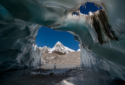
A guide exiting a carved-out cave in Nepal during a glacier exploration in 2019. (Photo courtesy of Dr. Jason Gulley)
While Gulley continues his role as a professor at USF, he has started to become more engaged in science communication. He emphasized how certain topics related to the environment receive inadequate attention, most often due to challenges scientists face when communicating to the public. Additionally, journalists usually don’t have a scientific background which hinders their ability to effectively convey these stories. Gulley has taken it upon himself to share these stories with international audiences using platforms such as National Geographic and other major publications. He aims to garner the level of credibility that he would receive if publishing a scientific report, while also making a contribution to the field of glaciology on a large scale.
“As scientists, we know more about how humans have messed up the planet than at any other point in history. But fewer people seem to understand or care about it than when I went to college in the 90s. We need to get more people to care for and understand the research. There aren’t a lot of scientists who also have technical exploration skills, so for me, one of the things that I felt like I've contributed is being able to draw from my ability to work as a scientist and as an explorer and use both of those backgrounds to inform each other. Over the last almost 20 years now, I’ve provided a very unique picture of how the plumbing system of glaciers actually works and I hope to share that information with as many people as possible,” Gulley said.
To learn more about Dr. Jason Gulley’s work, visit the School of Geosciences website.