Steven Fernandez, MA, GISP, CCM.
The University of South Florida College of Arts and Sciences’ Steven Fernandez, associate professor in the School of Public Affairs, has served as a source of knowledge and information for ESRI (ArcGIS)—a GIS software company specializing in interactive mapping tools—for the past two years, meeting with the company every few months to assist in improving their 3D products and provide knowledge on what he’s teaching in his lidar courses.
Now, they are using his work as examples of their company’s newest capabilities.
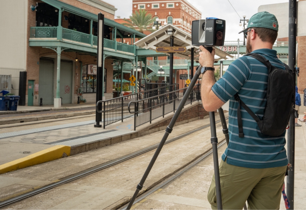
Lidar technology uses the light from a laser to collect measurements that can be used to create 3D models and maps of objects and environments.
“Lidar mapping involves laser scanning an object or landscape to get a high-resolution survey,” Fernandez said. “Lidar is used for flood mapping, forestry applications, urban design, self-driving vehicle operation, CGI in movies, and so much more.”
He says that more than 350,000 organizations and businesses worldwide use this type of software.
“The knowledge that ESRI asked for our data to test on their software made us very proud of the work we are doing here at USF,” he said.
One area that is using this type of technology is engineering and urban planning firms, Fernandez explained, which use the data to assist in planning, designing, and constructing the built and natural environment.
“Geospatial technology companies are becoming larger every day, due to the increased need for location-based services. This includes data collected from lidar,” he said.
Fernandez’s lidar course aims to equip students with the skills they will need to enter these fields.
“We think this course is a one of a kind here in the U.S.,” he said. “We have not been able to find a course like it at any of the universities that have lidar in their curriculum. This course is also unique in that it is different every year. The sites that we scan are of a different structure each summer.”
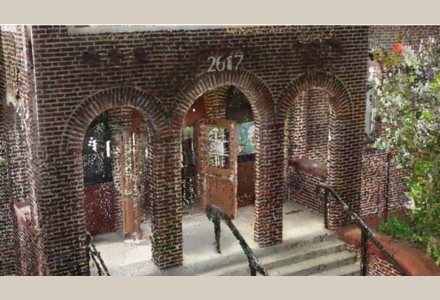
Screenshot of a terrestrial lidar point cloud in an ArcGIS Web Scene. This 3D data was used to show off the software’s increased point density rendering. (Photo courtesy of Steven Fernandez)
Fernandez’s students have assisted a variety of organizations with lidar data collection including Hillsborough County (Ybor Casitas), HART (streetcars), City of Tampa (Union Station and De Soto Community Center), Lee’s Grocery, and New World Brewery.
“Anyone with a thirst for technology and mapping is welcome to enroll,” he said. “No previous mapping courses are required, just a knowledge of how to use a Windows computer. We usually work in harsh conditions at industrial sites, in the middle of city streets or railroads, historical buildings, docks etc. Most sites are outdoors, so we also work in the heat of May and have to navigate the Florida storms while working.”
Fernandez is working on securing next summer’s site location but encourages all interested to join the course.
“Lidar technology is the next big game changer in mapping,” Fernandez said. “Just like GPS was in the 1990s. There are so many possibilities for future maps. It’s going to change our lives.”