Research
USF GeoPark
HISTORY OF THE GEOPARK
Dr. Len Vacher
Our GeoPark was born in the Fall of 2001, when Bob Bretnall (founding President of the Geology Alumni Society) and Chuck Connor in his first semester as Chair of the Department of Geology met with Steve Gift (Director of Facilities and Planning and head architect of USF) and others to propose that the plot of empty land south of Parking Lot 19 on the west side of campus be put aside as a resource site for on-campus geological teaching and research. The site, an exquisite example of the covered karst (see geological discussion by Mark Stewart that follows) that typifies and bedevils west-central Florida, had long been the subject of field study by Mark Stewart, Sam Upchurch, and Sarah Kruse, and their students and classes.
Following that initial meeting, the site was officially designated the Geology Alumni Society GeoPark, with the intention that it continue to be a focal point for on-campus teaching and research. In the grand plan, the site joins with the Botanical Gardens to anchor the west end of a greenway that will extend all the way to the east end of campus.
The 4th annual Geology Alumni Society Equipment Expo inaugurated the GeoPark on Feb 9, 2002. More than a hundred geologists and environmental scientists from the community visited more than a dozen exhibits and demonstrations, several of which featured geophysical surveys of the sinkholes that characterize the site. The 5th annual Geology Alumni Society Equipment Expo, on Feb 14, 2003, added a symposium of speakers under an exhibition tent. In 2004, the Expo will be the North American Environmental Field Conference and Exposition put on by the Nielsen Environmental Field School, Inc., on Jan 14-16, at the nearby Embassy Suites with field demonstrations at the GeoPark.
A short walk from the SCA building, the GeoPark continues to increase in its role as a demonstration site for a variety of courses including hydrogeology, geophysics, and geomorphology. The utility of the site is increased by the results of two MS theses: Diane Bloomberg, 1987 ("Cone-penetrometer exploration of sinkholes: Stratigraphy and soil properties") and John Parker, 1992 ("Surficial aquifer hydrogeology in a covered-karst terrane"). In addition, each Expo adds more wells, more geophysics lines, and more experience that becomes part of the teaching resource.
A central feature of the GeoPark now is "The Rock," a six-ton sample of the Ocala Limestone from Lecanto Quarry in Citrus County. Donated by Crystal River Quarries, Inc., and arranged and delivered to the site by alumni Gabrielle Enos, Tom Scott, Dave DeWitt, and Bob Bretnall (courtesy of the Florida Geological Survey and SWFWMD), The Rock provides an on-campus look at the Florida aquifer which is penetrated by some of the wells on the site. Arrival of The Rock on August 15, 2002, was cause for celebration by both students and alumni as another academic year was about to start.
The Geology Alumni Society and the Department of Geology plan for the GeoPark to evolve into an on-campus community education facility. On December 6, 2003, twenty-some alumni, graduate students and faculty braved 50-degree temperatures and mulched pathways in the vicinity of The Rock and wells installed for earlier hydrogeological studies. We are seeking funds to create and install educational signage along the pathways to explain the architecture and hydrogeology of the sinkholes; the Floridan aquifer and how it is recharged in this area of covered karst; the Florida-friendly vegetation and other water-resources matters exhibited by the site. We envisage that, in time, the GeoPark will be the destination of self-guided, environmental tours starting from the nearby Botanical Gardens and a quiet, educational respite within our busy campus.
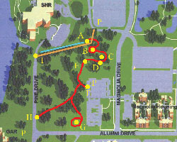
Trail Map
LEGEND
P - Parking
A - Hope Lodge Access Point/
Drainage Ditch Vantage
B - Floridan Aquifer Rock
C - Shallow Sinkhole Vantage
D - Surficial Aquifer Well
E - Floridan Aquifer Well
F - Magnolia Apartments Access Point
G - Deep Sinkhole Vantage
H - Botanical Gardens Access Point
I - Shriners Hospital Access Point
KARST CHARACTERISTICS OF THE USF GEOLOGY PARK, TAMPA FLORIDA
GEOLOGICAL SETTING
The USF GeoPark lies within the Atlantic Coastal Plain (ACP). The ACP is characterized by very low relief and typically has a shallow water table.
The ACP in Florida is underlain by a blanket of Miocene and post-Miocene siliciclastic deposits that overlies a thick sequence of Tertiary carbonates. This carbonate platform includes the Floridan aquifer.
The Floridan Aquifer is composed of Eocene to Miocene limestone and dolostone. The maximum freshwater-saturated thickness is about 700 m, and averages 300-400 m. The Eocene and Oligocene rocks are relatively pure carbonates, but Miocene units contain considerable siliciclastic material. The siliciclastic units of the Miocene Hawthorn Formation and the weathering residuum of the "dirty" Tampa limestone member form a semiconfining unit over the early Tertiary carbonates. Quaternary aeolian activity has reworked some of the shallow marine sediments, creating an uppermost layer of very fine, very well sorted sand.
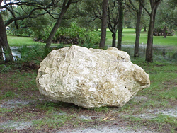
"The Rock"
KARST
Although west-central Florida does exhibit some classical fluvio-karst features, the siliciclastic cover, especially the dune sands, has subdued the surface expression of all but the largest features. Many karst features are relict, apparently formed when the water table was considerably lower than its present position. Many of the first-order springs of west Florida discharge through conduits formed by downward moving water when the water table was 100 m or more below land surface.
The insoluble residue of the Tampa Limestone and the fine-grained units of the Hawthorn Formation form a stiff clay cap over the underlying limestone. This cap is competent enough to bridge small cavities, but collapse of the clay into larger, pre-existing cavities creates an upward raveling through the unconsolidated sediments, forming a cover-collapse sinkhole. The result can be a vertical column of surficial sand extending from the surface into the limestone, through the semiconfining layer. The cover collapse can be slow, episodic or catastrophic. At the USF GeoPark, there is one mappable subsidence feature for every 625 m2 (25 x 25 m) of land surface.
The USF area is an active cover-collapse sinkhole region. The USF campus has experienced more than 30 cover-collapse events in its 40 years of operation. This results in a frequency of about one cover-collapse sinkhole per square mile per year. The small cover-collapse feature at well 4A in the GeoPark has collapsed three times since about 1980.
HYDROGEOLOGY
Because of the presence of the cover-collapse features and the downward hydraulic gradient, lateral flow of shallow ground water is limited. At the USF GeoPark, and probably in much of the Tampa Bay region, shallow ground water flows only a few tens of meters or less until it either discharges into a surface water body or finds a cover-collapse sinkhole, through which it then recharges the Floridan Aquifer.
By far, the greatest volume of recharge at the USF GeoPark moves through the karst conduits and not through the semiconfining layer. The study site is 12,000 m2. The sand columns contribute 16 m3/day of recharge; in contrast, about an estimated 1 m3/day is estimated to leak through the semiconfining layer. Thus the sand columns constitute about 1% of the surface area of the site, but contribute 95% of the recharge to the underlying Floridan Aquifer.
In terms of recharge, these cover-collapse features appear to be the dominant hydrostratigraphic features in west-central Florida.
REFERENCES
Parker, J. W., 1992, Surficial Aquifer Hydrogeology in a Covered-Karst Terrane, Masters Thesis, University of South Florida, 228pp.
Stewart, M., Parker, J., 1992, Localization and Seasonal Variation of Recharge in a Covered Karst Aquifer System, Florida, USA, International Contributions to Hydrogeology, vol. 13, Spinger-Verlag, pp. 433-460.