Programs
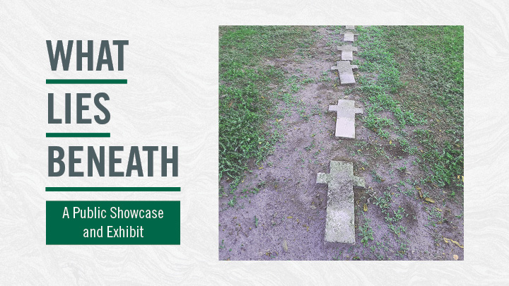
What Lies Beneath
USF’s Institute for Forensic Anthropology & Applied Science presents
“What Lies Beneath: The Search for Unmarked Burial Grounds in Hillsborough County"
ABOUT THE EXHIBIT
The exhibit, What Lies Beneath, presents the results of a multi-year interdisciplinary investigation into unmarked burial grounds in Hillsborough County undertaken by Dr. Kimmerle and her Ph.D. candidate Kelsee Hentschel-Fey, along with GIS Manager Benjamin Mittler, and Dr. Lori Collins of the USF Center for Digital Heritage and Geospatial Information.
Their re-discovery and identification of more than forty cemeteries and burial grounds previously lost to history were identified in the survey, are the subject for the exhibition that is now shared with the public. The exhibit offers a unique view into the history of the area told through the lens of its cemeteries, utilizing historic and modern photographs, archival documents and maps depicting the approximate locations of newly re-discovered burial grounds, and mixed media sculptures to help convey the story of the buried past.
Burial grounds and cemeteries are recognized as important public spaces and links to the past, but many of these locations are lost, forgotten, or erased and are no longer part of the living social memory. In 2019, two African American cemeteries built over in Tampa in the 1950s exemplified this concept: the Zion Cemetery located on Florida Avenue property owned by the Tampa Housing Authority, and the Ridgewood Cemetery located on the grounds of King High School, owned by the Hillsborough School Board Authority. The re-discovery of these cemeteries prompted the Hillsborough Board of County Commissioners (HBCC) to question whether there were additional unmarked cemeteries on county owned property. An in-depth investigation into the location of unmarked graves was undertaken for HBCC.
Through that research project, a GIS approach used a combination of archival, ethnographic, bioarcheological, remote sensing and forensic archaeological methods to identify possible cemeteries and burials throughout the county. Through this effort, the team found references to over forty additional burial grounds, four of which were relevant to county-owned lands. Among the additional findings, several sites date to the 1860s, and are on lands granted through the Freedman’s bureau following the Emancipation, representing early Black settlements throughout the area. A portion of the sites are family burial plots that fell out of living memory as generations passed. There are also cemeteries that were in use until modern times and then removed, or erased, from the landscape and omitted from maps and written documentation through numerous land transactions that essentially forced a state of abandonment. Analysis of that data show that at least eighteen or 44% of the sites located, the cemeteries or sections of the cemeteries are Africa American, Afro-Cuban, or were classified as “Colored” during the era of segregation.
3D Cape Canaveral Space Force Station - Quarterman South Cemetery
This video shows surface and subsurface features using 3D laser scanning and GPR at Cape Canaveral Space Force Station historical cemetery. The video features an unidentified ledger stone above a burial subsurface, three known/marked burials, and one potential unrecorded burial location. This is a prime example of how surface and subsurface surveys can be used to help reveal "what lies beneath". Made by the USF Center for Digital Heritage and Geospatial Information.
Acknowledgements
The exhibit was created by USF students taking Dr. Kimmerle’s museum studies class, “Race, Memorialization and the Museum”. Special thanks are given to Liotta Noche-Dowdy, Chris Turner, Tuesday Frasier, Kara DiComo, Natalie Wise, Bronte Phillips, Caitlyn Figueroa, and Gennifer Goad for their help and effort constructing this exhibit.
Citation and Disclaimer
Kimmerle EH, Hentschel-Fey K, Mittler B, and Collins L. 2023 “Findings for field verification using GPS and remote sensing technologies to corroborate historic research results”. Report and Presentation to the Hillsborough County Board of County Commissioners (August 16, 2023).
GIS Data Disclaimer: GIS data is provided as a public service. Every effort is made to provide accurate and complete data. No data should be used without first reading and understanding the limitations of the data. USF Libraries Center for Digital Heritage and Geospatial Information provides NO WARRANTY as to the accuracy of this data or any corresponding attributes or metadata. Data is provided in an “as is” condition, without warranty of any kind, either expressed or implied, including any assurance that the data is fit for a particular purpose. USF shall have no liability, in any case, to the use of provided data (including redistribution and reproduction). Full liability, responsibility and consequence relating to the use of provided data rest with the user.