Written By: Dyllan Furness, Science Communication Manager | The Florida Flood Hub
From the air to sea, small things can have big impacts on our planet.
Aquatic microorganisms known as phytoplankton serve as photosynthesizing powerhouses, producing more than half of Earth’s oxygen. Aerosols — often-invisible particles suspended in the atmosphere — can have significant influence on Earth’s climate, weather, public health, and ecology.
A new NASA mission called PACE (Plankton, Aerosol, Clouds, ocean Ecosystem) will help scientists better understand the ocean and atmosphere, including interactions between phytoplankton and aerosols.
Equipped with state-of-the-art instruments, PACE gathers data that will help researchers study phytoplankton blooms, better understand air quality, and advance the science behind ocean health and its impact on the planet more broadly.
Several scientists with close ties to the USF College of Marine Science (CMS) have been integral to the PACE mission, which was launched from the Kennedy Space Center on Cape Canaveral in February 2024. In April, the satellite reached a new milestone known as “first light,” when the first data was collected and released to the public from the orbiting satellite. Images from the “First Light” Gallery can be viewed on the PACE website.
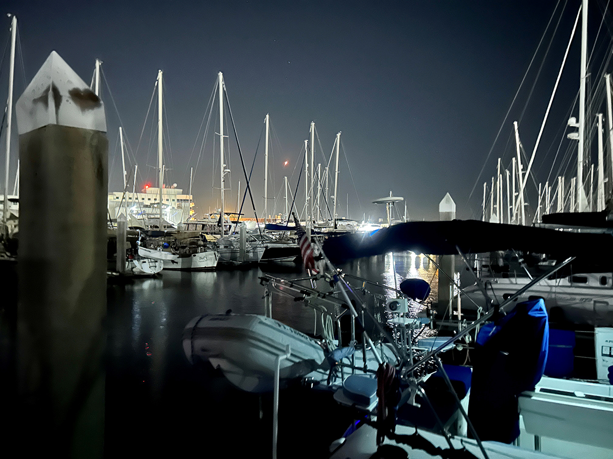
After two cloud delays, PACE launched at 1:33 a.m. on February 8, 2024. The rocket can be seen here from the docks near the USF College of Marine Science. PHOTO CREDIT: Brooke Longval.
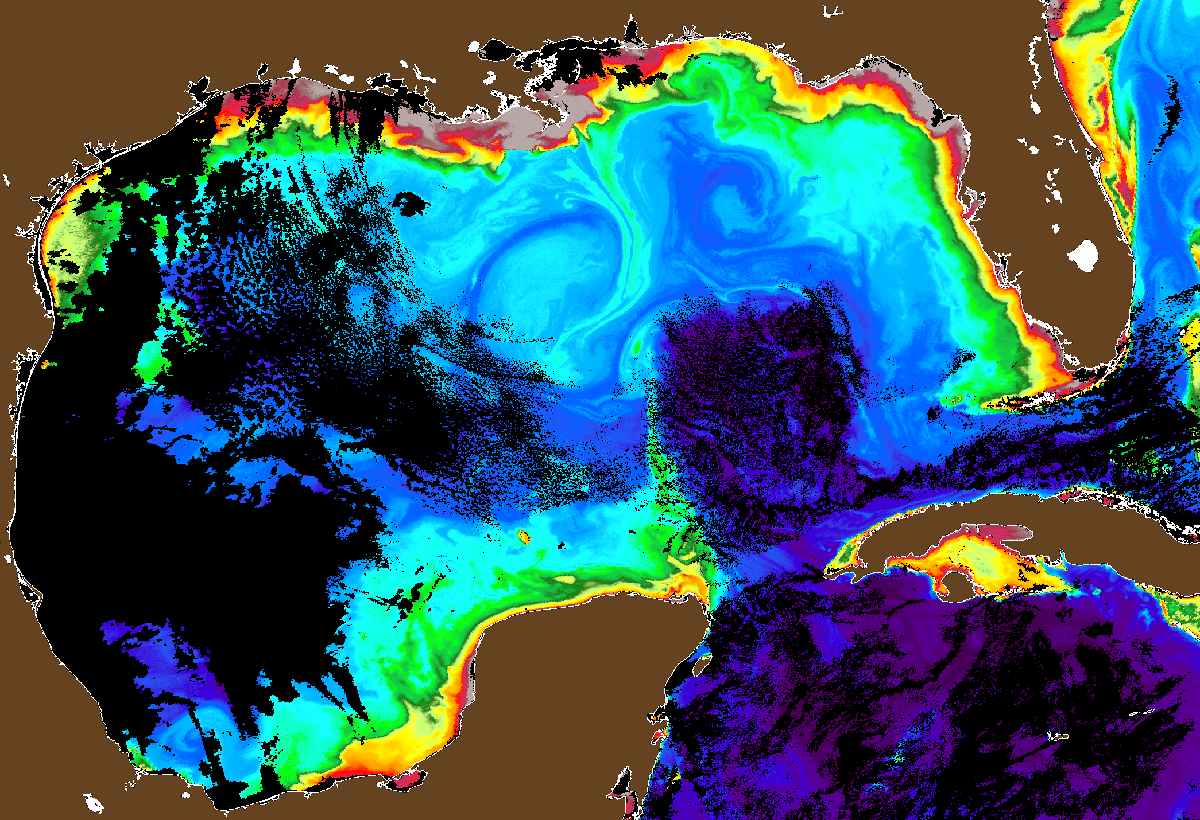
New views of ocean color
Advancing ocean and atmospheric science is key to the PACE mission. The main instrument on the satellite is a cutting-edge tool called the Ocean Color Instrument (OCI), a hyperspectral imaging radiometer that measures properties of light in the electromagnetic spectrum at finer wavelength resolution than other NASA satellite sensors. The OCI will give researchers unparalleled views of the ocean.
The PACE satellite is also equipped with two multi-angle polarimeters that measure polarized light reflected off clouds and tiny particles in the atmosphere.
Previous NASA satellite sensors detected between three and 16 colors at a handful of wavelengths. The OCI picks up a whopping 128 colors at more than 200 wavelengths including those beyond detection of the human eye.
“Thanks to instruments like the OCI, PACE will be collecting data that has never before been collected,” said Brian Barnes, an assistant research professor at CMS who has been involved in the PACE mission as a member of its Science and Applications Team.
For PACE, Barnes will look at shallow waters such as those around the Florida Keys. These relatively clear and shallow ecosystems are a habitat sweet spot for marine plants and animals — coral, seagrass, algae, and sponges reside there — but these waters can be difficult to assess from satellite data.
“Traditional ocean color research focuses on deep oceanic waters, where the bottom is not visible,” Barnes said. “In optically shallow waters, light reflecting from the seafloor environments complicates this scheme. My project for PACE has been to disentangle the signals the satellite receives about the atmosphere, water, and seabed, so we can determine how deep the water is, what’s in the water column, and what’s on the bottom.”
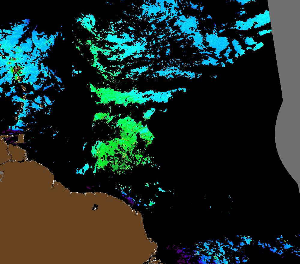
PACE captured this floating algae index image around the Lesser Antilles on April 16, 2024. The elongated and swirled features represent Sargassum mats and rafts. PHOTO CREDIT: The Optical Oceanography Lab.
Chuanmin Hu, professor at CMS and director of the Optical Oceanography Lab, is an expert in using remote sensing tools such as satellites to study the ocean. As a member of PACE’s Science and Applications Team, he says PACE will help take some of the guess work out of ocean color remote sensing.
“In ocean optics, we often rely on local knowledge to determine what we observe from satellites,” he said. “Now with PACE, we have more spectral bands and can determine what something is by studying its spectral shape. This will allow researchers to easily distinguish floating materials such as Sargassum, litter, and cyanobacteria.”
Hu’s work with the PACE mission will include deciphering Sargassum physics, biology, and physiology through PACE measurements. He said one of the hurdles for the PACE mission moving forward is how best to handle the sheer volume and size of data the satellite sends to Earth.
“A typical digital photo might be three megabytes but an image of hundreds of spectral bands from PACE may be two gigabytes,” he said. “That is a challenge for the scientific community – how to work on those data and process them in an efficient way.”
From CMS to NASA
Laura Lorenzoni is an oceanographer who serves as the program scientist for PACE. She earned both her PhD and master’s degrees at CMS. Now at NASA, Lorenzoni ensures PACE’s science addresses the agency’s goals.
“PACE is a trailblazing ocean color and atmospheric mission,” she says. “Now that PACE is flying, it is up to me at NASA HQ, together with our program applications lead, to provide opportunities to our scientists for them to take advantage and exploit the remarkable data PACE will produce.”
Lorenzoni said PACE will help scientists:
- Extend key systematic ocean color, aerosol, cloud, and terrestrial climate data records.
- Identify and quantify specific phytoplankton groups.
- Understand the role that phytoplankton diversity has on life in the ocean and expand our ability to do marine biodiversity research.
- Study the relationship between the ocean and the atmosphere.
- Better understand carbon exchange and sequestration between the atmosphere and the ocean.
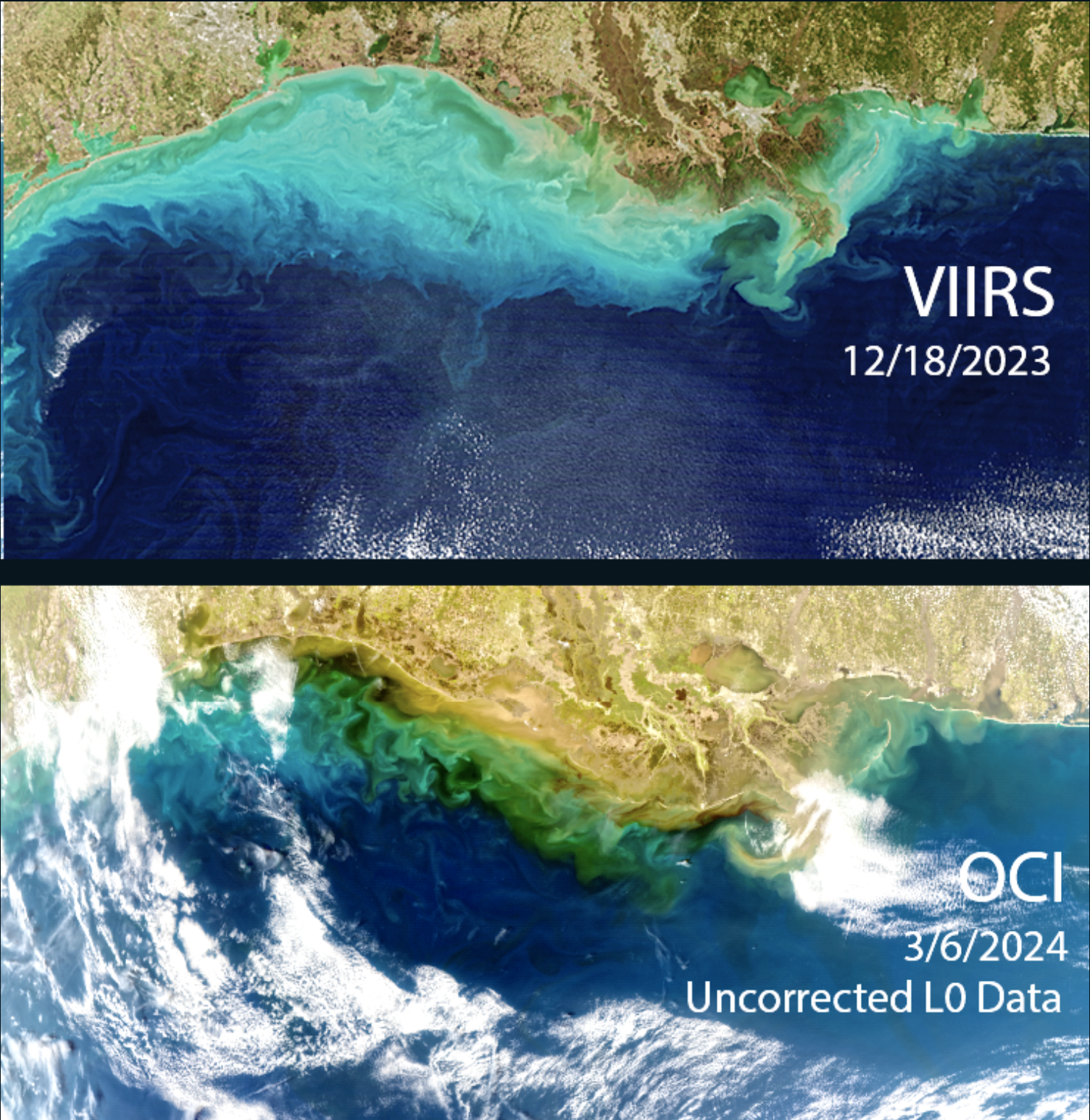
PACE is equipped with trailblazing technology that sets it apart from other Earth-observing satellites. The bottom image depicts the level of detail in a Mississippi River plume captured by PACE compared to another satellite instrument a few months prior. PHOTO CREDIT: NASA.
An important part of the PACE mission is data validation, or making sure the satellite’s data matches up with data collected in the field, so that everyone can trust the PACE data.
Inia Soto Ramos, another CMS alum, plays a pivotal role for PACE as an associate researcher and one of the mission’s data validation leads at NASA’s Goddard Space Flight Center Ocean Ecology Laboratory. Soto Ramos earned her PhD and master’s degree at CMS, and in a recent “People of PACE” profile, she described how ocean color science has allowed her to study the sea from space for nearly two decades.
“I’ve used ocean color imagery since 2005, when I started doing my PhD,” Soto Ramos said. “It helped me study coral reefs and the connectivity among different coral reef communities, and how river plumes can go from one reef area to another reef area. Then, I moved into studying phytoplankton from space and creating algorithms to detect harmful algal blooms.”
As part of PACE’s science and validation teams, Soto Ramos helps confirm the quality of PACE’s data through direct observation.
“PACE data is compared with similar measurements collected in the ocean and atmosphere to make sure they agree; and that process is called satellite validation,” she said. “In addition to being a part of the science team, I help the validation team by making sure we have enough field data to validate PACE data. This process allows us to know how good the data is and whether there any issues that need to be resolved. Once we know the data is good, we can use it to create algorithm to derive satellite products that are meaningful to the public and scientific community, such as water and air quality products.”
Many other researchers affiliated with CMS will leverage PACE data. At the CMS Institute for Marine Remote Sensing, Frank Müller-Karger and his team will use PACE data to study different functional groups of phytoplankton. Both Laura Lorenzoni and Inia Soto graduated from Muller-Karger’s Institute for Marine Remote Sensing at CMS.
Marina Marrari, who earned her PhD at CMS and currently serves as director of the Costa Rica Fishing Federation, has worked with Brian Barnes to see how PACE data can help track red tide data for recreational fishers in Costa Rica.
What these researchers all have in common is a desire to unlock the secrets of the ocean and an excitement for using machines like PACE to look at our planet in ways never before possible.