Written by: Tim Dixon & Jay Law
ST. PETERSBURG, FL – On August 23rd a University of South Florida research team and numerous partners completed the successful deployment of the first Shallow Underwater Buoy for Geodesy (SUBGEO) system designed to measure seafloor uplift in coastal areas prone to earthquakes and tsunamis. The test deployment here in Tampa Bay represents a significant step forward in an ambitious 3-‐year project funded through the National Science Foundation (NSF).
The complicated deployment was executed flawlessly, a testament to the hard work and close collaboration of the many research team members, which included local and international industry partners, university researchers and state and federal agencies. These include the USF School of Geosciences and College of Marine Science, Orion Marine Group, Florida Institute of Oceanography (FIO), Port Tampa Bay, the Tampa Bay Harbor Pilots Association, Florida Department of Environmental Protection, US Coast Guard Sector St Pete and District 7 Miami, the Italian Institute of Geophysics and Volcanology (INGV), UNAVCO, and Hydra Solutions Engineering.
The tragic earthquake/tsunami sequences of 2004 in Sumatra and 2011 in Japan were catastrophes that produced respectively the most fatalities and the largest financial losses from a natural disaster in recent history, and were wake-‐up calls that the science community has not been very successful at forecasting these tragic events. The buoys being designed and tested by the USF-‐led team will enable precise measurements of sea floor motion to be made in the months and years prior to these events, and should allow for improved forecasting ability, especially for the largest tsunamis, which are the real killers.
The project is made possible through an NSF-‐OTIC (Ocean Technology) grant to develop
a high precision sea floor geodetic system suitable for shallow coastal regions (less
than 200 meter water depth). The system is designed for subduction zone applications
(such as the Pacific “ring of fire” where offshore strain accumulation and release
processes are currently poorly monitored. The strain measurements in these offshore
areas are needed for earthquake and tsunami forecasts, and for improved understanding
of the earthquake process. In some subduction zones, including Central America, the
continental shelf area that is shallower than 200 meters covers 30%-‐40% of the sea
floor area between the coastline and the trench. Hence the new buoy design should
have wide applicability.
The SUBGEO system uses a high precision GPS system to measure vertical displacements
to an accuracy of approximately 1 cm. It was designed in close collaboration with
INGV-‐Italy, the government agency charged with volcano hazard assessment. INGV pioneered
the use of such systems in the Gulf of Pozzuoli in southern Italy to monitor dangers
associated with nearby Campi Flegrei and Mt Vesuius volcanoes (Vesuvius was the volcano
that destroyed the Roman town of Pompeii in AD 79). Enhancements to the Italian design
will allow the USF buoy to also measure horizontal motions of the sea floor to high
accuracy.
The system engineering was completed by Hydra Solutions of Casalserugo Italy who designed earlier versions of these buoys in collaboration with INGV. With the addition of heading and tilt sensors to allow for the recovery of horizontal components of deformation the system will be capable of recovering the full three-‐dimensional displacement vector of a point on the seafloor to an accuracy of 1-‐2 cm averaged over 24 hours. Electronic and system engineering were undertaken by the USF CMS Ocean Technology Group and USF Geodesy Lab.
The buoy and anchor were constructed at the USF College of Marine Science’s machine
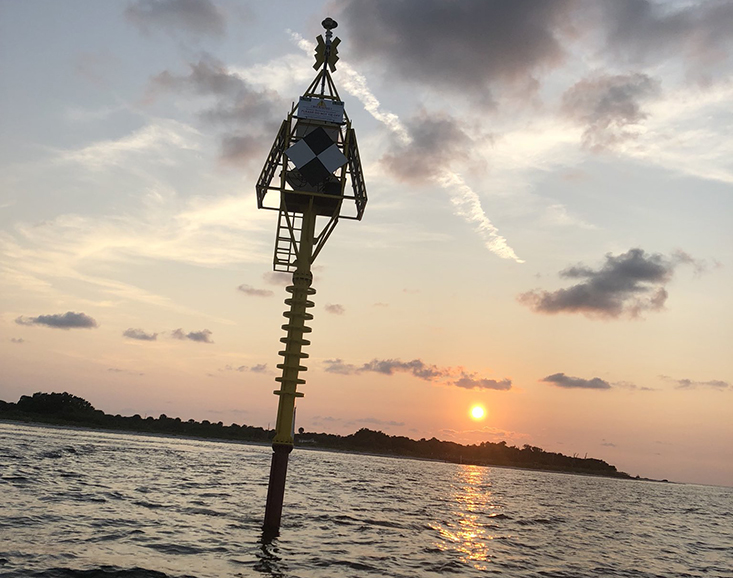
shop facility. The figure below shows the buoy design and specifications. At approximately
100 feet long and deployed in 65 feet of water, the buoy rises 35 feet above the waterline.
The concrete anchor weighs over 50,000 lbs in air and has an in-‐water weight of
nearly 30,000 lbs. The float provides 26,000 lbs of buoyancy, After correcting for
the weight of the buoy itself, this leaves a net positive buoyancy of nearly 20,000
lbs, keeping the spar buoy upright in the water column despite strong winds and currents.
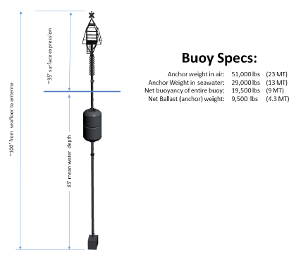
Buoy Specs
The buoy was deployed on August 23, 2018 inshore of Egmont Key. The deployment was
executed by the experienced crew of Orion Marine Group, using a 150-‐foot barge equipped
with a 250-‐ton crane. Vessel support was provided by the Florida Institute of Oceanography’s R/V Hogarth and R/V Price. A project of such large scale and ambition has required years of collaboration
and cooperation between USF researchers and engineers, international partners and
local agencies. The professional execution of the deployment further underscored the
exemplary teamwork of the many dedicated professionals in the Tampa Bay region. The
system was deployed, electronics installed and data collection begun within 12 hours
of arrival on site.
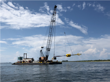
Tsunami buoy being deployed in Tampa Bay
The next 6 months will see a complete test of the system. Raw GPS data will be downloaded
weekly, with high precision GPS calculations post-‐processed after high precision
satellite orbit information is received from NASA’s Jet Propulsion Lab in Pasadena,
California. Weather system data, particularly wind speed and direction, will be used
to assess effects on buoy tilt, which can impact the accuracy of the GPS measurements.
USF engineers are working on posting the weather data online in real-‐time for use
by boaters and other end users. The buoy represents an ultra-‐stable platform complete
with solar power at a location of ecological and oceanographic interest at the mouth
of Tampa Bay, and has elicited interest from other researchers for a variety of purposes.
These include red tide research, fish and mammal migration studies, ocean circulation
applications (especially useful for hazardous material tracking at this busy port
entrance) and search and rescue operations.
For more information, check out our project web site: (click on the “Research Projects” button)
For inquiries on additional uses of the buoy, contact Jay Law.
For inquiries on scientific applications, contact Tim Dixon.