
By: Dyllan Furness, Director of Communications
As Hurricane Idalia approached Florida’s Big Bend in August 2023, warm waters of the Gulf fueled its growth. In less than 24 hours, the storm jumped from a Category 1 to a Category 4 in a phenomenon known as rapid intensification.
Idalia is not alone in the annals of supercharged storms. Recent hurricanes such as Milton (2024), Helene (2024), and Ian (2022) rapidly intensified before their devasting landfalls. In each instance, the sudden increase in strength made the ultimate impact difficult to predict.
A recent study led by researchers at USF’s College of Marine Science shows that water discharged from rivers can play a role in this phenomenon. Data about freshwater plumes could help experts improve hurricane forecasts.
Coastal communities rely on accurate forecasts to make critical decisions about boarding up buildings and evacuating homes. Despite continued improvements in hurricane modeling, rapid intensification remains a challenge for forecasters.
Sea surface temperature, ocean heat content, and wind shear can influence a storm’s sudden gain in strength. But these factors alone fail to explain Idalia’s intensification, according to the recent study published in Environmental Research Letters.
Wind conditions during Idalia’s period of rapid intensification were not as favorable as they were earlier in the storm’s development, the authors state, “raising the question of what external factors contributed to its extreme intensification during this phase.”
To answer the question, the authors analyzed a plume of freshwater that stretched from Mississippi to Florida’s Panhandle and south to the Florida Keys, which created conditions that were ripe for intensification. Discharged from rivers along the Gulf Coast, this plume formed a thick surface layer of low-density, low-salinity water that resisted mixing with the rest of the water column.
The result: warm surface water stayed warm and fueled the storm.
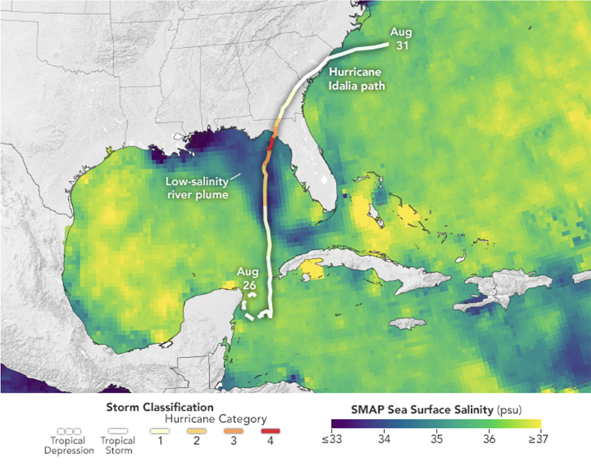
IMAGE ABOVE: In late August 2023, a low-salinity plume of freshwater stretched from Mississippi to the Florida Keys. Hurricane Idalia’s path and classification is also shown. In a recent analysis of Idalia, researchers demonstrate how this river plume may have influenced the storm’s rapid intensification. Credit: NASA Earth Observatory
“Water mixing is a natural process typically driven by winds,” said Chuanmin Hu, professor of oceanography at the USF College of Marine Science and an author of the study. “Winds mix warm, shallow water to the depths and bring cool, deep water to the surface. This mixing of deep and shallow water helps keep the sea surface temperatures down and removes some of the fuel storms depend on. However, during Idalia, the density difference between the freshwater on the surface and salt water down below made mixing more difficult.”
Read more: How a USF glider helped forecast Hurricane Helene
The findings were somewhat serendipitous. Hu and his colleagues, including researchers from the college’s Optical Oceanography Lab, Ocean Technology Group, and the University of Miami, intended to study phytoplankton and dissolved matter in river plumes using data from satellites and underwater gliders. The data they gathered on the thick layer of freshwater proved valuable in understanding Idalia’s intensification.
Prior studies have pointed to the influence of river plumes on the intensity of tropical storms in other areas of the globe. A paper from 2007 found that more than two-thirds of Category 5 storms between 1960 and 2000 traversed the vast plumes of the Amazon and Orinoco Rivers in South America.
For Hu and his co-authors, a key takeaway from their recent study is the importance of integrating river plumes into hurricane forecasting.
“Accurate forecasting is critical for people to plan as a storm approaches,” Hu said. “Our study demonstrates the value of considering the influence of river plumes on storm intensification. If there’s a persistent river plume in the right location at the right time, you might have the perfect conditions for a powerful storm.”