Written by Sean Beckwith, PhD student
ST. PETERSBURG, FL – Red tides are extremely disruptive to the environment and to people living and working along the coast. Tools exist to verify the presence of red tide and predict its movements, but continuation of these predictions depends on reliable support for deployment and maintenance of oceanographic instruments, for analysis of the data, and for fundamental research.
Critical areas farther off the west coast of Florida are rarely sampled for red tide, which means that we perpetually lack the predictive capability to alert us of incoming blooms and their severity. Innovative methods and instruments may now give us the ability to detect red tide at its onset, to know the extent and severity of a bloom, and to quickly and accurately analyze water samples for the presence of the organism responsible for red tide. Better understanding of the current and future state of red tides are realistic. However, reductions in funding for scientific infrastructure have stymied efforts to monitor, predict, and assess these harmful blooms. A resurgence of support for the scientific capabilities that have been developed specifically to respond to red tide would improve environmental management and societal tolerance of these harmful algal blooms. As a supplier of innovation in this realm, the University of South Florida College of Marine Science (USF CMS) draws on its decades of experience, infrastructure, and products to answer the most pressing questions in its mission to create lasting, large-scale solutions that will mitigate future blooms.
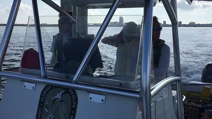
Researchers from FWC’s Fish and Wildlife Research Institute, Matt Garrett (right) and Eric Muhlbach (left), along with Steve Butcher (center, background) from the CMS Ocean Technology Group, get an early start from Clearwater Beach to deploy a glider that will autonomously record and transmit water quality parameters related to red tide.
How does a red tide begin?
Red tides, a term given to blooms of a microscopic organism named Karenia brevis, originate in deeper waters offshore and manifest themselves in shallower waters as they become concentrated along the coast. Ocean circulation patterns play a major role in the occurrence or absence of red tides as upwelling is created through prolonged interactions between the Gulf of Mexico Loop Current and Florida’s broad, shallow continental shelf. Upwelling brings nutrients from deeper portions of the Gulf to the shelf waters. In the case of red tide, it’s sort of a Goldilocks situation in that a lack of upwelling might not provide enough nutrients for K. brevis while too much upwelling allows faster growing organisms to outcompete K. brevis by feasting on the abundant nutrient supply.
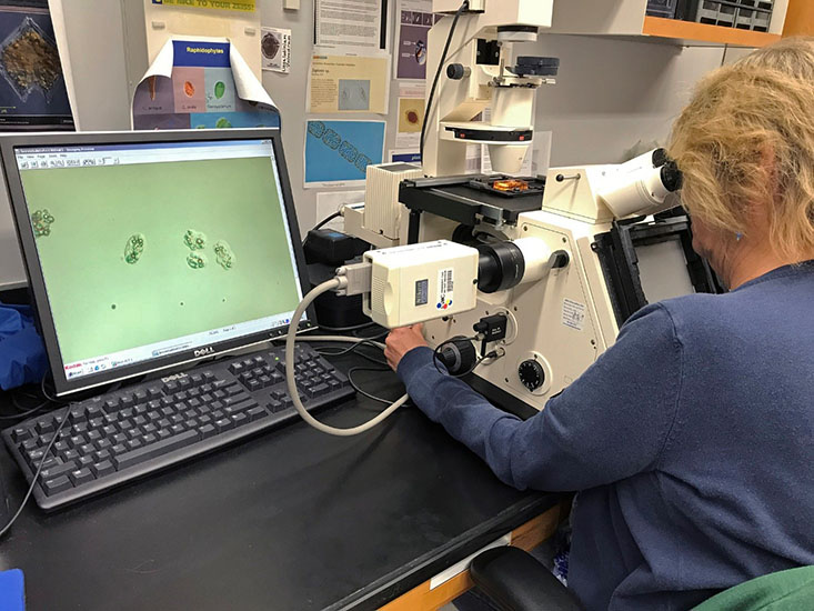
A microscopist with FWC’s Fish and Wildlife Research Institute analyzes a sample containing Karenia brevis (displayed on the screen). Photo courtesy of FWC.
For a bloom to initiate, K. brevis requires the sanctuary conditions that deeper waters
offshore provide: ideal water chemistry and vertical space to avoid light stress
at the surface. However, once formed, a bloom of the organism tends to prevail, often
to the point of excess. Once ocean currents have transported a bloom to the shallow
coastal waters, individuals find protection from light stress owing to higher concentrations
of Color Dissolved Organic Matter (CDOM). CDOM provides a bit of shading for K. brevis,
analogous to how tea particles obscure the bottom of a cup of tea.
What other factors contribute?
Terrestrial runoff carries nutrients from both natural and man-made sources to the coastal waters. In an advanced state, a harmful algal bloom (HAB), such as red tide, does not show signs of being outcompeted by other, faster-growing organisms. Instead, the bloom takes advantage of all the nutrients available, including land runoff and nutrients from decaying fish (specifically ammonium) that were victims of the bloom itself. Peak conditions and the dissipation of blooms is currently being studied further. Tools are available to understand the impacts of offshore nutrient concentrations on blooms, as well as to predict the time to shore and severity of red tides.
What tools are available to understand and predict red tide?
Dr. Robert Weisberg, physical oceanographer at USF CMS, points out that monitoring potential blooms at offshore locations is presently the most important use of scientific funding because it is the only way to effectively predict red tide.
“It’s a combination of looking at larger scale circulation to see whether or not the West Florida Shelf is conducive or not to a major bloom, and, once we have a bloom, use observations to trace where that bloom may be heading,” said Weisberg.
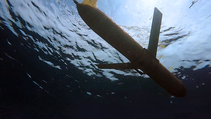
The most robust way to monitor a large area at multiple depths (and the cheapest) is with gliders. Auto-controlled and torpedo-like, they glide effortlessly through the water column on battery power for up to a month. Transmitting their data via satellite to researchers and engineers at the CMS Ocean Technology Group, they can provide a first-responder assessment of possible blooms. Small boats, operated by the Florida Fish and Wildlife Commission’s Fish and Wildlife Research Institute (FWC-FWRI), then carry HAB specialists to the most efficient locations to sample for the red tide organism, K brevis. Models run by the Ocean Circulation Lab at USF CMS use the sampling data from FWC to provide 3.5-day forecasts of the path of a bloom and its concentration at various locations.
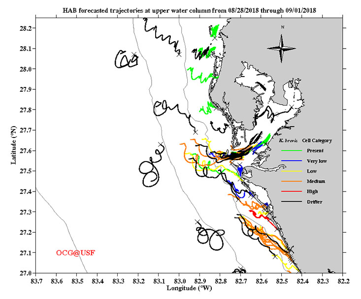
Forecast from the USF Ocean Circulation Group. Trajectories (starting at x’s) show the path of water particles over the next 3.5 days. Colored trajectories are for actual red tide samples taken at those locations.
The research group also makes seasonal predictions of red tide bloom based on a hypothesis that interactions of the Gulf of Mexico Loop
Current with the shelf slope under certain conditions can reset the West Florida Shelf
nutrient structure in ways that may prevent bloom development. An altimetry derived
offshore forcing index—a measure of how strongly the Gulf of Mexico Loop Current system
interacts with the continental slope and induces upwelling on the shelf—may serve
as a seasonal predictor for major K. brevis blooms on the west Florida coast.
![Twenty-five years of data compiled by the Ocean Circulation Group showing comparisons of red tide occurrence and offshore forcing at the “pressure point”, which leads to upwelling. Adapted from Liu et al. [2016]](/marine-science/news/images/twenty-five-years-of-red-tide-data-compiled-by-the-ocean-circulation-group.jpg)
Twenty-five years of data compiled by the Ocean Circulation Group showing comparisons of red tide occurrence and offshore forcing at the “pressure point”, which leads to upwelling. Adapted from Liu et al. [2016]
“We found that for 20 out of the past 25 years, in which we have concurrent data,
we can actually predict the existence, or non-existence, of a major bloom simply on
the basis of the ocean circulation,” shared Weisberg.
Overlaying the model simulated currents and alga concentration data, Dr. Chuanmin Hu’s Optical Oceanography Laboratory at USF CMS produces a near real-time Integrated Red tide Information System (IRIS). From their website, anyone can access the satellite imagery files and click on links below the images to open multi-layer maps in Google Earth for all coastal regions of the eastern Gulf of Mexico (Louisiana to the Florida Keys). Dr. Hu’s lab uses unique combinations of spectral bands from satellite data to monitor red tide from Earth’s orbit. From this vantage point, and depending on cloud cover, the entire extent of a red tide bloom can be viewed in daily satellite imagery.
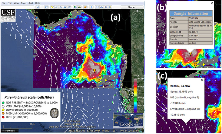
The Integrated Red Tide Information System pulls together a number of tools including satellite imagery, ocean circulation models, and water sampling data.
“The advantage is the synoptic coverage. We know the size. For example, the current
red tide as of yesterday is more than three times Tampa Bay in size,” said Hu, referring
to the size of the bloom about a week ago. However, as of the writing of this article,
the bloom is now estimated at four times the size of Tampa Bay.
On the ground, Dr. John Paul, a microbiological oceanographer at USF CMS, detects the presence of K. brevis with an instrument that quantifies its RNA.
“We use something called NASBA, which stands for Nucleic Acid Sequence Based Amplification,” said Paul as he explained the method by which his device uses fluorescence to single out K. brevis. “The time that the amplification occurs is inversely proportional to the concentration.”
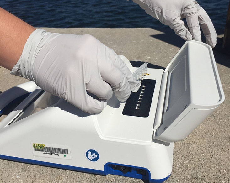
The Red Tide Chek being readied to process samples in the field. Photo courtesy of Dana Nieuwkerk.
With extremely low error and simultaneous analysis of eight water samples, the Red Tide Chek (also known as the Red Tide Tricorder) can rapidly and accurately quantify K. brevis,
with no crossover from non-target organisms. This game changing tool is currently
used in comparative analyses by FWC-FWRI and is readily available to state and federal
agencies, the shellfish industry, and other end-users.
Dana Nieuwkerk, a Ph.D. student working with Dr. Paul, added, “What’s really nice about this platform [referring to the portable Tricorder] is that you’re able to take the instrument in situ. You can take the instrument on a boat and do testing and come back from a cruise with near real-time data, rather than having to go out and archive samples and bring them back to later analyze them…It’s battery powered, so you can bring it to the beach and run samples right there.”
How do red tides finally dissipate?
There are a few theories that explain the end of a red tide bloom; it is likely a combination of these ideas that provides the full answer. Theories in the scientific community include 1) advection of a bloom to nutrient-depleted locations, which eliminates the organisms’ food source and reduces their population to levels that might be outcompeted, 2) hurricanes and winter swells that mix the water column, which disrupts and dilutes a bloom of K. brevis, and 3) a theory involving terminal cell response signals that cause individuals to limit their own production, perhaps as a mechanism of self-preservation.
A “cure” for red tide does not presently exist. However, multiple tools for mitigation are available: early detection and prediction of bloom movements, visualizations mapping the complete spatial extent of a bloom, and rapid analysis of water samples. Karenia brevis is a very successful species by evolutionary criteria. Blooms will continue to return on a regular basis, but as a society, there is much more to be done to better prepare our coasts for locals and visitors.