Carlyn Scott, College of Marine Science
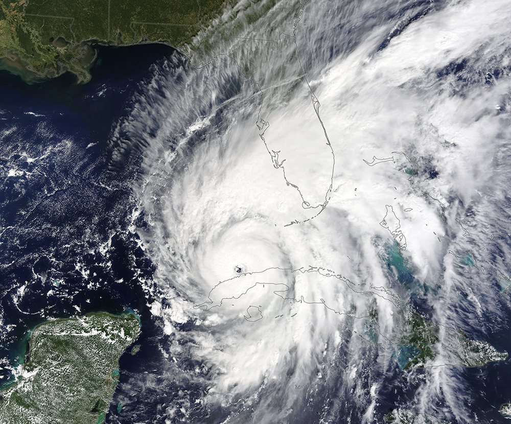
Driven by high temperatures in the Gulf, Hurricane Ian rapidly intensified from a Category 3 to Category 5 before making landfall in Southwest Florida on September 28, 2022. The deadly storm caught many by surprise and became the costliest hurricane in state history.
Now, researchers from the University of South Florida say they’ve identified what may have caused Ian to develop so quickly. A strong ocean current called the Loop Current failed to circulate water in the shallow region of the Gulf. As a result, subsurface waters along the West Coast of Florida remained unusually warm during the peak of hurricane season.
The findings, published in Geophysical Research Letters, may be used to make more accurate predictions about hurricane intensity.
In the Gulf, rapid intensification typically occurs over deep waters that can store abundant heat energy. But Hurricane Ian was different. As the storm neared landfall, it intensified over the shallow West Florida Shelf, which is normally kept cooler thanks to ocean currents.
This anomaly intrigued researchers at the USF College of Marine Science’s Ocean Circulation Lab.
“We wanted to understand how the warm subsurface waters of the West Florida Shelf were able to persist all summer,” said Yonggang Liu, associate professor and lead author of the recent study. “What were the conditions in the Gulf that allowed these temperatures to develop in the first place?”
Liu and his team turned to data they’ve gathered over several decades through the Coastal Ocean Monitoring and Prediction System (COMPS), an array of surface buoys and bottom-mounted moorings across the shelf. COMPS, which receives funding from the National Oceanic and Atmospheric Administration (NOAA), provides real-time measurements of ocean currents, salinity, and water temperature to the scientific community.
The researchers found that if the Loop Current reaches an area near the Dry Tortugas, which they call the “pressure point,” it can flush warm waters from the West Florida Shelf and replace it with cold water from deeper regions of the Gulf. This pressure point is where the shallow contours of the seafloor converge, forcing cold water to the surface in a process known as upwelling.
In the months leading up to Hurricane Ian, the Loop Current did not reach the pressure point, leaving the waters on the shelf unmixed, which caused both the surface and subsurface waters on the West Florida Shelf to remain warm throughout summer.
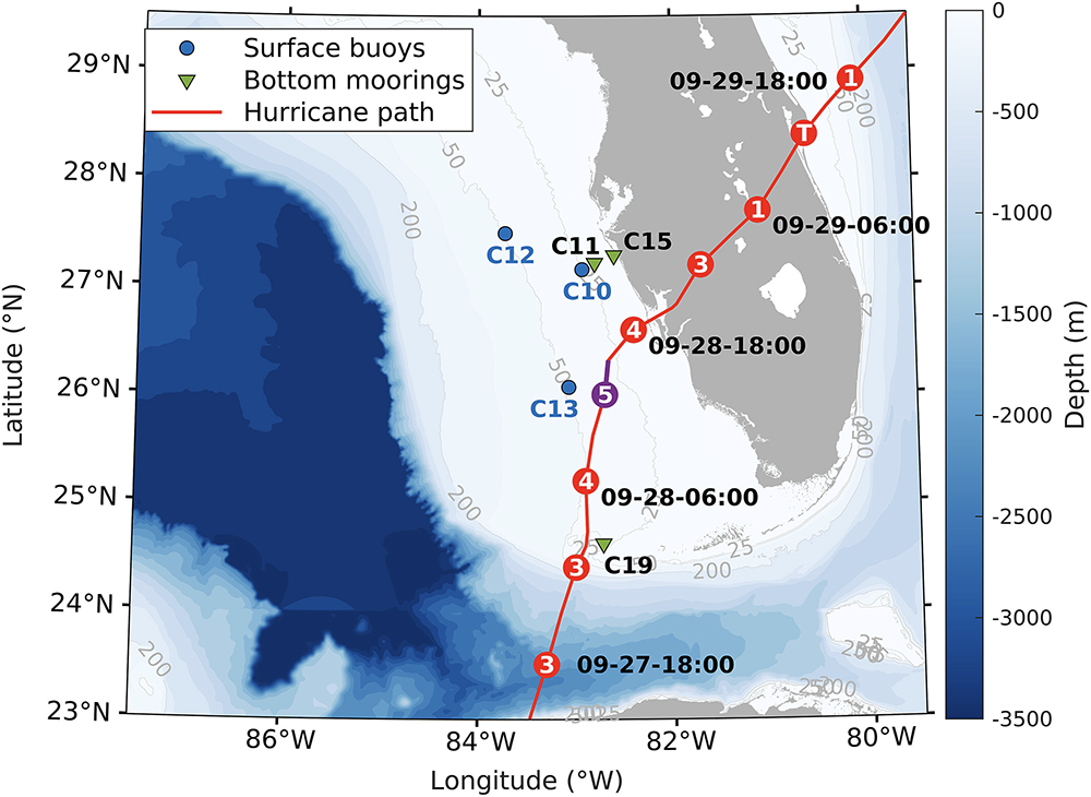
IMAGE ABOVE: The path of Hurricane Ian as it increased in intensity along the coast of Florida. Buoys and moorings deployed by the Ocean Circulation Lab picked up valuable water temperature data. Image credit Liu et al., 2025.
“Typically, there is a mixing of the water column where warmer surface waters interact with the underlying, often cooler subsurface water,” said Liu. “But in this case, the shelf water was not able to cool down because the Loop Current did not initiate any upwelling.”
Read more: How rivers fuel hurricanes — and how that knowledge can improve forecasts
The temperature of the subsurface layer of water is important for forecasters to monitor, according to Liu, as sea surface temperatures only give a glimpse into the heat available for hurricanes. Prior to Hurricane Ian, surface waters were only 1 – 2°C warmer than average, while the subsurface waters were 2 – 3°C warmer.
“By not including the subsurface water temperature in models and forecasting, we are not getting the entire picture of the water column and the potential energy for hurricanes,” Liu said.
Measurements made by COMPS allowed Liu and his colleagues to examine the long-term trend of ocean temperature and currents on the West Florida Shelf, including the influence of the Loop Current on the region.
This study highlights the importance of monitoring subsurface temperatures for heat content along the coast, and points to the value of coastal observation programs for the resilience of the state and nation. COMPS partners with NOAA’s Integrated Ocean Observing System (IOOS) through the Southeast Coastal Ocean Observing Regional Association (SECOORA) to improve such oceanic observations in the Gulf.
“The more real-time observations we have of the entire water column, the better predictions we can provide, and the safer our communities will be,” Liu said. “This type of monitoring provides more complete data to predict intensity of future storms.”